Cruising South
Saying good-by to AYB
We finally push off and head south. The plan is to cruise
the Intracoastal Waterway (ICW) as much as possible with a few long days
offshore to bypass some of the gnarly sections. We plot the cruise plan into
the Navionics software on the iPad and then enter each day’s course into the
navigation software on Bravo’s computer. Because the days are getting shorter,
we have less practical travel time each day. We plan to cover about sixty miles
a day to make our Florida arrival date goal.
Southern Virginia… North Carolina… Alligator River
We depart AYB at dawn. Virginia slips by and the canal
quickly delivers us into North Carolina. Day one covers wide straight stretches
of water. The weather is grey and rainy. Another tropical storm is swirling
offshore over the Atlantic Ocean. Very few boats on the canal equals relatively easy cruising. We make good time and decide to proceed several miles
past our initial goal and anchor at sunset in a wide stretch of the Alligator
River. The calm evening quickly changes to winds of 50-60 knots. This is a much
stronger storm than predicted. We take turns on watch to be sure the anchor
does not drag. Luckily, no other boats are anchored anywhere in sight. Bravo is free to swing in the direction the wind blows and the anchor holds all
night. We are happy to see the sunrise and the winds drop down to 20-25 knots. We raise the anchor and continue on our way.
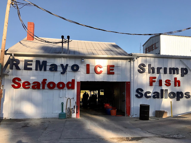
RE Mayo Seafood
We are still making good time so once again we continue past our
original planned destination, Bellhaven, and spend the night on the dock of a seafood
company in Hobucken, North Carolina. The mooring fee is very reasonable and
they have fresh shrimp! Really fresh right off the boat docked behind us. Nora
cooks them up with lots of butter and garlic for a really tasty dinner. We also
pick up scallops and crab cakes for future consumption. Throughout the evening, local fisherman come and go in small boats uniquely constructed to navigate the shallow swampy fishing grounds.


We are still making good progress and planned to anchor in
Swansboro, but the bay was filling up with a collection of sailboats traveling
together so we opt to moor at Casper’s Marina. Very appropriate since it is
Halloween!
Wrightsville Beach
On the move again as soon as the sun is up. Canal navigation
is getting a little more challenging. Narrow sections and shoaling from storms creates conditions where the charts and reality do not coincide. One of us
steers while the other person watches the depth sounder, water conditions and
works the radio for calling bridges, other boats that are passing us, or that we are passing. We arrive
at our planned destination, Wrightsville Beach and drop the anchor for the
night.
Change in plans, ...again
Our original destination for today is North Myrtle Beach. Challenging
canal conditions continue and we cross the Cape Fear River sharing the shipping
lanes with large container ships. We find a wonderful little town dock in
Holden Beach and decide to stop early today. We tie up Bravo and walk across
the street to the Atlantic Ocean beach. It is a warm sunny day. Time for fish
and chips lunch at the local seaside eatery and a walk on the beach. The town
dock also has a super clean free laundry and showers. Today is a catch up on
some R&R. We also decide to alter the cruising plan and head offshore
tomorrow for a long distance short cut to Charleston, South Carolina.


Offshore to Charleston, South Carolina
A short distance from Holden Beach is an inlet that opens to
the Atlantic Ocean. We make a left turn and we are out into deeper waters. The
weather and sea conditions are great and we head southwest to Charleston. We
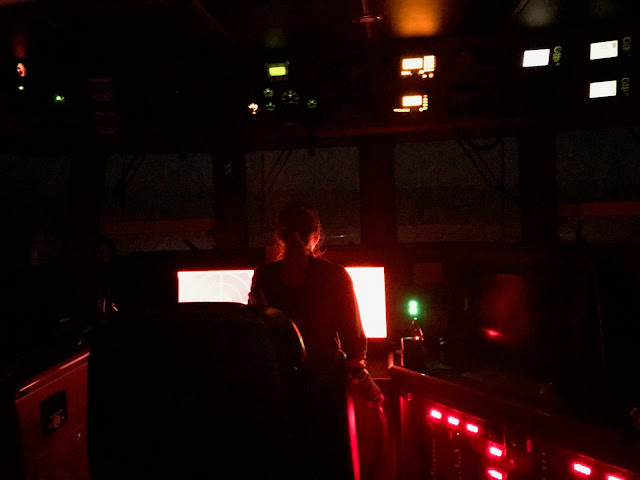
arrive after dark, and we use the FLIR night vision, as well as the instructions from the Active Captain app, and our trusty
cruising buddy, Gale, to anchor off of Fort Jefferson. Our initial plan is to stay here
until our friends Chet and Lynette arrive. We put the dinghy in the water and
cruise around the harbor checking out the historic waterfront and the
Charleston Harbor Marina Resort. We make a plan to move to their docks when our
friends arrive. However, the weather windows are again dictating a change in schedule. We
consult with our friends and alter the plan. They will meet us in Jacksonville
instead of Charleston. We will make a really early departure the following morning
and continue south to Beaufort, South Carolina.
Offshore to Beaufort, South Carolina
Since we mastered arriving and anchoring in the dark, we are
now departing in the dark. Four thirty AM and following the harbor red and
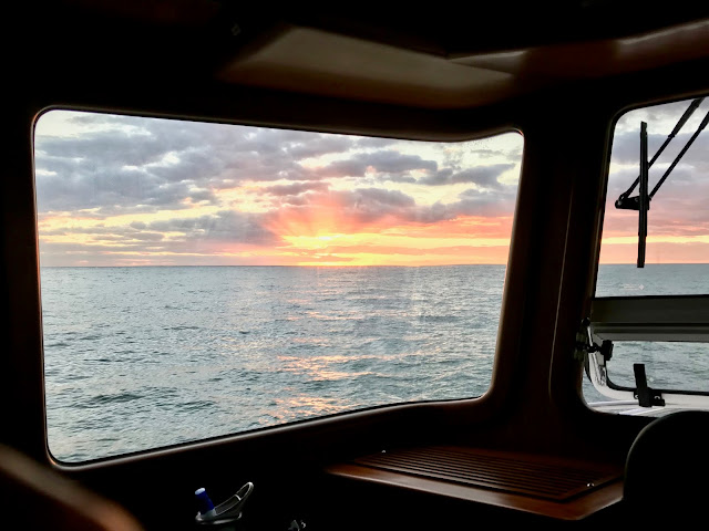
green channel lights leads us out into the Atlantic. The sun comes up as we
exit the long harbor channel, turn right, and head south. Arriving at sunset,
we find the anchorage, drop the hook, and settle in for the night.
Offshore to Brunswick, Georgia
This is starting to be a routine. Up at 3:45AM. Pull anchor
and cruising by 4:30AM. Follow the red and green lights out to the ocean, turn
right and head south. Follow the buoys back to the harbor. Anchor. Eat. Sleep.

Offshore to Jacksonville, Florida
Early start again. This is a shorter distance day, but we
want to arrive early to get fuel and check out Fort George Island Marina where
we plan to stay until Chet and Lynette arrive. Approaching the channel
entrance around 10:00AM, we appear to be arriving at a very busy time. The VHF
radio is buzzing with conversations between Coast Guard cutters, Canadian
warships, pilot ships, tugs, barges and other commercial traffic all vying for
use of the long narrow harbor entrance channel. We
join the parade and head up the channel. Luckily, the marina we plan to use is
just inside the harbor entrance and circling once to hang the fenders, we tie
up to the fuel dock. Once the tanks are
topped off, we move forward to a face dock and tie up.
We are sure glad we got tied up when we did. As the tide starts to go
out, the current in the harbor reaches about 4.5 knots. Water is flowing past the
boat like rapids in a river. Careful fender positions and spring lines help
keep Bravo in proper position to the docks.
St. John’s River and Naval Station Mayport
Directly across the river is a Navy base complete with a wide assortment of Navy warships including an aircraft
carrier and a helicopter pilot training center. Three or more helicopters are
constantly circling the harbor and conducting touch and go landings. Gigantic
container ships, cruise ships, barges, tugs, fishing boats, and pilot ships go in and out 24/7 right in front of us. This is a busy harbor.

Lots of these large ships which are car carriers for the east coast car manufacturers.


Container ships.

Shrimp boats.

Cruise ship, and Bravo with our blue exterior courtesy lights on.
Fort George Island
The Fort George Island Marina staff are terrific and provide
details of historical sites nearby. Across the street and down a long country
road are two historical sites. The Ribault Club, and Kingsley Plantation. The
island also was the home to the Native American Timucua tribes who, in 1562,
greeted the first Europeans led by French explorer, Jean Ribualt. The native tribes lived here
for thousands of years and the midden piles filled with oyster shells are still
visible along the road and walking paths. Over the years, the French, Spanish,
and English fought over this territory and the Native American tribes succumbed
to a variety of diseases introduced by the Europeans.


Haven’t seen an update recently... are you adrift somewhere Karl? You should head over to Nassau, Bahamas next week - I will be there for a while. Dave
ReplyDelete